A COMPREHENSIVE PLAN for
FORT PAYNE, al
Fort Payne—a city of roughly 15,000 residents located in the mountains of northeast Alabama—has a rich cultural history, a strong manufacturing base, and unique natural assets tied to Lookout Mountain, Big Wills Valley, and the Trail of Tears. The city’s population is slowly growing, household incomes remain modest, and most residents rely on work outside the city, signaling an imbalance between local jobs and housing. We found that Fort Payne’s development pattern has shifted over time from a compact, historic downtown to a spread-out, highway-oriented pattern that weakens walkability and strains infrastructure. Community input revealed concerns about dangerous and congested corridors—especially AL-35 and areas around the Norfolk Southern rail line—limited housing diversity, aging neighborhoods, a lack of transitional-density housing, and an underutilization of natural assets and cultural landmarks. Residents also emphasized the need for safer transportation infrastructure, more trails and park access, stronger economic opportunity downtown, and preservation of agricultural and natural landscapes that define the city’s character.
The planning team recommended a coordinated strategy that strengthens Fort Payne’s identity while guiding growth in a safer, more sustainable, and connected pattern. We recommended improving major corridors—particularly Gault Avenue and AL-35—through streetscape upgrades, access management, walkability improvements, and a highway flyover to eliminate rail-related congestion and safety hazards. We advised expanding and diversifying the park system with new parks on Big Wills Creek, a Lookout Mountain overlook, a multi-use sports complex, and greenways that link neighborhoods to regional recreation assets. To support quality growth, we recommended updating zoning citywide to encourage infill development, neighborhood commercial nodes, a broader mix of housing types, and environmentally sensitive development on the mountain and along waterways. We also recommended focusing industrial recruitment around the airport corridor, redeveloping key city-owned sites—including the former hospital property—expanding tourism infrastructure tied to Trail of Tears sites, and using branding, gateways, and wayfinding to elevate the city’s profile as an outdoor recreation and cultural destination.
Figure 1: Recommended highway branding and pedestrian connectivity improvements

Figure 2: Proposed gateway corridor improvement strategies

Figure 3: Conceptual infill and multi-use trail connectivity plan for outdated strip mall property

Figure 4: Recommended complete streets improvements for the city's main highway spine

Figure 5: Recommendations to improve downtown connectivity across the railroad

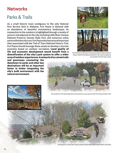
Figure 6: Proposed expansion of park network to highlight mountaintop views and Trail of Tears historic site
Fort Payne FORWARD
See Full Comprehensive Plan
